
By Dhani Irwanto, 18 October 2015
Progo Valley Civilization
Progo Valley, or sometimes called Kedu Valley, is the fertile volcanic plain that lies between the volcanoes, Mount Sumbing and Mount Sundoro to the west, and Mount Merbabu and Mount Merapi to the east of Central Java, Indonesia. The plain also borders the Menoreh hills in the southwest and Prambanan Plain in the southeast. The Progo River runs through the center of this plain, from its source on the slope of Mount Sumbing to the southern coast of Java facing the Indian Ocean. It has been a significant location in Central Javanese history for over a millennium, as it contains traces of the Sailendra dynasty as well as Borobudur and associated locations. According to local myth, the Progo Valley is a Javanese ‘sacred’ place and has been dubbed “the garden of Java” due to its high agricultural fertility.
The island of Java is an elongated stretch of land, more than 1000 km long and about 100 km from north to south. Its northern coast, facing the Java Sea, is bordered by an alluvial plain, the width of which may vary, in Central Java, from 40 km, to a few kilometers. Further inland, parallel to the coast, runs the impressive North Serayu Ridge. Its main summits are, from west to east, Slamet (3432 m), Ragajembangan (2177 m), Prahu (2565 m) and Ungaran (2050 m). The North Serayu Ridge is continued to the east by the Kendeng Hills, which reach 899 m. South of these mountains lies the central depression zone of Java, which encompasses plains of varying size, such as the plains of Purwokerto, Magelang, Yogyakarta, Solo, Purwodadi and Ngawi. The depression zone is partly capped by a series of high volcanoes: Mounts Sundoro (3155 m), Sumbing (3371 m), Merbabu (3145 m), Merapi (2947 m) and Lawu (3265m). The Central depression zone is further divided by the presence of the South Serayu Mountains and the Menoreh Hills. In most parts of the island, the Central depression zone is bordered to the south by the Southern Mountains, a steep mountainous chain that prevents access to the Indian Ocean.
In Central Java, however, with the exception of its easternmost part, the central depression zone is not bordered by mountains. The plains gently slope southward to the ocean. Historical Central Java, which encompasses the Progo Valley and its direct surroundings, constitutes a transition zone between the closed, mountainous landscape of the west and the open plains of the east. From a geographer’s point of view, it is the border between Central and East Java.
The Serayu River begins on Mount Sundoro and flows westwards through the Wonosobo-Purwokerto plain, until it reaches the Indian Ocean in the neighborhood of Cilacap. The Progo River is the main watercourse of historical Central Java. Unlike the other rivers that originate from the Central depression of Java and run east or westwards, the Progo River flows directly from north to south. Its source is located high on Mount Sundoro, while its main tributary, the Elo River, takes its source on Mt Merbabu.
The Progo Valley hosts a large number of Dharmist and Buddhist temples dated from the 8th to the 9th century. Because of this, the Progo Valley is considered the cradle of classic Indonesian civilization. The temples in the region include as follow.
Borobudur: The gigantic 8th century stone mandala Buddhist monument was built by the Sailendras.
Mendut: The 8th century Buddhist temple is housing three large stone statues of Vairocana, Avalokiteshvara, and Vajrapani.
Pawon: The small 8th century Buddhist temple near the bank of Progo River is located between Mendut and Borobudur.
Ngawen: The 8th century Buddhist temple is located about 5 kilometers east of Mendut temple.
Banon: The ruins of a Dharmist temple; located several hundred meters north of Pawon temple. However, no significant remains of the temple have survived, thus, its reconstruction is impossible. Only the statues of Shiva, Vishnu, Agastya, and Ganesha have been discovered, which are now displayed at the National Museum of Indonesia, Jakarta.
Canggal: also known as Candi Gunung Wukir. One of the oldest Dharmist temples in the area. The temple is located in the Muntilan area, near the temple a Canggal inscription connected with Sri Sanjaya, the king of Medang Kingdom was discovered.
Gunung Sari: The ruins of a Dharmist temple on top of a hill, located near Candi Gunung Wukir, on the outskirts of Muntilan.
Umbul: in Grabag, Magelang; it served as a bathing and resting place for the kings of Mataram.

Figure 1. Distribution of temples in central Java
More than 300 temple remains were once visible in Central Java, scattered all over the region. Today, however, a large part of these ruins has vanished. Some of them were used as stone quarries to build new houses, mosques or bridges. Others were simply victims of the ravages of time or were buried under residues from human activities. The situation is scarcely better for the majority of the remaining sites: many former temples have been reduced to a few dozen stones scattered in a field or along a road. On the other hand, certain buildings were relatively well preserved and anastylosis granted them a new life. Restored from top to bottom, these temples are now waiting to be visited and admired.
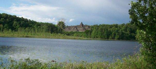
Borobudur Temple
The Borobudur Temple Compounds is one of the greatest Buddhist monuments in the world, and was built in the 8th and 9th centuries AD during the reign of the Sailendra Dynasty. The monument is located in the Progo Valley, in the southern part of Central Java, at the center of the island of Java, Indonesia.

Figure 2. Borobudur Temple
The main temple is a stupa built in three tiers around a hill which was a natural center: a pyramidal base with five concentric square terraces, the trunk of a cone with three circular platforms and, at the top, a monumental stupa. The walls and balustrades are decorated with fine low reliefs, covering a total surface area of 2,520 m2. Around the circular platforms are 72 openwork stupas, each containing a statue of the Buddha.
The vertical division of Borobudur Temple into base, body, and superstructure perfectly accords with the conception of the Universe in Buddhist cosmology. It is believed that the universe is divided into three superimposing spheres,kamadhatu, rupadhatu, and arupadhatu, representing respectively the sphere of desires where we are bound to our desires, the sphere of forms where we abandon our desires but are still bound to name and form, and the sphere of formlessness where there is no longer either name or form. At Borobudur Temple, the kamadhatu is represented by the base, the rupadhatu by the five square terraces, and the arupadhatu by the three circular platforms as well as the big stupa. The whole structure shows a unique blending of the very central ideas of ancestor worship, related to the idea of a terraced mountain, combined with the Buddhist concept of attaining Nirvana.
The Temple should also be seen as an outstanding dynastic monument of the Sailendra Dynasty that ruled Java for around five centuries until the 10th century.
The Borobudur Temple Compounds consists of three monuments: namely the Borobudur Temple and two smaller temples situated to the east on a straight axis to Borobudur. The two temples are Mendut Temple, whose depiction of Buddha is represented by a formidable monolith accompanied by two Bodhisattvas, and Pawon Temple, a smaller temple whose inner space does not reveal which deity might have been the object of worship. Those three monuments represent phases in the attainment of Nirvana.
The temple was used as a Buddhist temple from its construction until sometime between the 10th and 15th centuries when it was abandoned. Since its re-discovery in the 19th century and restoration in the 20th century, it has been brought back into a Buddhist archaeological site.
Borobudur was mentioned in Serat Centhini, a twelve volume compilation of Javanese tales and teachings, written in verse and published in 1814. Worldwide knowledge of its existence was sparked in 1814 by Sir Thomas Stamford Raffles, then the British ruler of Java, who was advised of its location by native Indonesians. Borobudur has since been preserved through several restorations. The largest restoration project was undertaken between 1975 and 1982 by the Indonesian government and UNESCO, following which the monument was listed as a UNESCO World Heritage Site.
Borobudur is still used for pilgrimage; once a year, Buddhists in Indonesia celebrate Vesak at the monument, and Borobudur is Indonesia’s single most visited tourist attraction.

Figure 3. Cross section of Borobudur Temple. A: soil fill; B, C and D: horizon layers.
Mount Merapi Eruptions
Merapi (2911 m) is perhaps the best known volcano around Borobudur basin. It belongs to a group of four stratovolcanoes that includes Ungaran, Telomoyo and Merbabu volcanoes. Merapi is the most active volcano of the Indonesian archipelago and it is believed to be the most dangerous as well, with a virtually continuous activity that shades serious threats over local inhabitants (egNewhall et al, 2000; Thouret et al, 2000). Hence, Merapi has been the object of numerous studies of its recent eruptions (eg Charbonnier and Gertisser, 2008; Gomez et al, 2008; Lavigne and Thouret, 2003), its evolution and eruptive history (eg Andreastuti et al, 2000; Camus et al, 2000; Gertisser and Keller, 2003a; Kalscheuer et al, 2007; Newhall et al, 2000; Voight et al, 2000), and associated hazards and risks (eg Lavigne et al, 2008; Thouret et al, 2000).
The collapse of an Old Merapi edifice was accompanied by a cataclysmic explosive eruption that laid waste to the surrounding countryside (van Bemmelen, 1949). Adopting an idea that was advanced first by Ijzerman (1891) and Scheltema (1912), and embellished by van Hinloopen Labberton (1922), van Bemmelen argued that the collapse and eruption occurred in 1006 AD and weakened the Medang civilization of Central Java, causing it to move from Central to East Java. Subsequent eruptions built a New Merapi that largely filled the collapse crater. Wirakusumah et al (1980, 1989) produced a geologic map that recognized the same Old and New Merapi, and added a preliminary radiocarbon chronology; Wirakusumah et al (1986), Bronto and Sayudi (1995), Bronto et al (1997) and Andreastuti et al (2000) added important stratigraphic details.

Figure 4. Geology of Merapi as inferred by van Bemmelen (1949)

Figure 5. Geological Settings of Merapi (Rahardjo et al, 1977)
Merapi has a complex history with different stages, for which different explanations were proposed (eg Berthommier, 1990; Camus et al, 2000; Gertisser and Keller, 2003b; Newhall et al, 2000). In front of this diversity, we chose to adopt the following timeframe for practical purposes, even though the findings necessitate a re-evaluation of the age dates proposed in literature: (1) a first period from late Holocene to present; (2) Old Merapi from ~10.000 BP to HPS; (3) Proto-Merapi, for everything earlier than ≈10.000 BP, using ‘proto’ in its original meaning.
The most recent phase, on which all authors agree, is characterized by pyroclastic flows and lahars accompanying growth and collapse of the active summit lava dome. Although historic events tend to stay on the flank of the edifice, Holocene pyroclastic-flow deposits cover wide areas and form most of the volcano’s apron.
This first period overlies thick basaltic andesite lavas intercalated with pyroclastic deposits of an older volcanic edifice, which scientists named Old Merapi. There is no precise dating of the beginning of the Old Merapi stage. Newhall et al (2000) propose a date of 9630 ± 60 years BP (14C dating) and Gertisser (2001) a slightly earlier date of 11,792 ± 90 years BP. Little is known about this period, however Andreastuti et al (2000) has identified for its late phase (3000 BP to 250 BP) a series of subplinian, plinian and volcanian eruptions, whilst present events are dominated by dome-collapse related events.
This older part of the volcano (Old Merapi) is characterized by a horseshoe-shaped Somma rim, oriented to the west, upon which the theory of one or several sector collapses and resulting debris avalanches is constructed. This idea was first suggested by Ijzerman (1891), then Scheltema (1912) and finally embellished by van Hinloopen Labberton (1922). In 1949, van Bemmelen adopted this idea and discussed the collapse of an Old Merapi edifice around 1006 AD, which would have been the cause for the Medang civilization’s shift of power towards the East. However, Newhall et al (2000) summarized archeological evidence that the decline of the kingdom of Medang in Central Java did not occur in 1006 AD, but almost a century earlier, and suggested a much older date for a Merapi flank collapse: 1900 ± 60 years BP. This date was challenged by Camus et al (2000), who proposed a collapse between 6700 and 2200 BP. It should be noted that all these attempts to constrain the timing of an Old Merapi collapse (and associated debris-avalanche deposits) are based on indirect evidence, as any debris avalanche deposit that could be associated with such an event is yet to be found. It may be that any debris-avalanche deposit, if it exists, may be buried under more recent deposits (Newhall et al, 2000). Indeed, Candi (temple in Indonesian) Sumbersari – 10 m high – was buried in less than a thousand years under clastic material, and 2.5 m of Candi Kedulan were buried in ~400 years. Thus, debris-avalanche deposits are not likely to appear in outcrops, if any.
The available literature also nurtured the idea of an early lake in the Borobudur basin, located to the west of Merapi Volcano, which would have been impounded around 660 ± 110 14C years BP (Newhall et al, 2000) by a potential debris avalanche. Murwanto et al (2004) embellished this idea based on a few 14C age determinations, extending the presence of a lake from the Holocene until historic times.
Volcanic activity at Merapi certainly began earlier than the Old Merapi stage described above. Berthommier (1990) and Camus et al (2000) argue that the volcanic development started as early as the late Pleistocene with an ‘Ancient Merapi’ stage (or ‘Proto-Merapi’ stage; Newhall et al, 2000), ~40.000 years BP, based on U-Th dating performed on basalts of Gunung Turgo/Plawangan.
This early stage of Merapi would have been built above an even older basaltic andesite volcanic structure, Gunung Bibi, dated by the K/Ar methods at 670,000 ± 250,000 years BP (Berthommier, 1990; Camus et al, 2000). This interpretation of an older volcanic edifice is still controversial, because it is based on a single age date only, with a significant error margin. In fact, Newhall et al (2000) argue that Gunung Bibi could be a young parasitic cone of Merapi.
Geology of Borobudur Basin
Located in central Java, 30 km to the North of Yogyakarta city, Borobudur basin is the depression that lies between Merapi and Merbabu volcanoes to the East, Sumbing volcano to the North and the Menoreh mountains to the West and the South. As a result, Borobudur basin is partially filled with clastic material intercalated with fluviatile (Figure 6) and lacustrine deposits (Murwanto et al, 2004; Newhall et al, 2000). The Progo River, and its main tributary, the Elo River, drains the Borobudur basin, cutting steep banks into the basin fluvio-lacustrine sediments and volcanic material.

Figure 6. Location of the Borobudur basin and location of the four deep cores (after Gomez et al, 2010)

Figure 7. Geological profile of Progo Valley (after Murwanto and Subandrio, 1997)
Alluvial plains in the middle of the valley, around the Silang and Progo rivers, comprise loose gray, blackish-brown material from the eruptions of Mt Mrapi and Mt Sumbing, and the frozen andesitic rocks of the Menoreh Mountain Range. The lithology (rock) of the Borobudur area at the north-west, north-east, and south-east is Quaternary rock from the Sumbing, Merbabu, and Merapi volcanoes respectively; on the northern side is the volcanic breccia of Mt Tidar. On the west side, there are diorite porphyry rocks and in the south is the volcanic breccia of old andesitic formation. Murwanto (1996) said that in the middle area, on the surrounding Borobudur hills, are clay sand materials, gray-blackish in color, formed by the Borobudur paleolake, which is covered by a pyroclastic layer of recent age from the Merapi volcano.
The sandy mudstones found in this area are lacustrine sediments, loaded with pollen from the plants of swamp habitats deposited in the Borobudur basin until the end of the 13th century. The sediments are exposed at the lower valleys of the Progo, Elo, and Sileng Rivers. On top of the sandy mudstone are deposited brownish-gray lapilli tuffs containing fragments of porous, compact pumice with a thickness of more than ten meters, due to Quaternary volcanic activity in the north (Murwanto 1996).
The ecosystem of the area is also affected by the mount of ‘Menoreh’, from an old Javanese word meaning ‘tower’ (Soekmono, 1976), part of the formation of the Kulon Progo mountains, an area that provides water to the Progo Valley. Menoreh hill is a Tertiary-age volcanic formation. The Menoreh hill soils are prone to land movement and landslides, especially in areas that are relatively steep, because they are composed of thick clay mixed with sandstone and weathering andesite breccia. In the dry season, the hill soils are porous and easily cracked. Moderate-intensity rainfall for two hours is enough to trigger landslides on the Menoreh hill.
Elevated land in the Borobudur area reaches an altitude of approximately 200 – 350 meters above sea level. The majority of land is relatively flat, with an undulating slope up to 0 – 7°. The steep areas with gradients of 25 – 40° are mostly located in the Menoreh Mountains.
The geomorphology of the Borobudur area, according to Van Bemmelen (1970), was formed by the tectonic processes of plio-pleistocene orogenesis in the late Tertiary period, around one to two million years ago. As a result of the ongoing process from the beginning until now, the Tertiary sedimentary basins of Kulonprogo folded, lifted, and faulted, forming the dome of Kulonprogo. On the northern side, the Kulonprogo dome structure is interrupted by multilevel normal faults and forms the canyon and cliff of the Menoreh Mountain, which extends east to west for nearly twenty kilometers. The fault of the northern part of the Kulonprogo dome block is immersed below sea level, while some of its top rises up, creating a row of isolated hills (ie the hills of Gendol, Sari, Pring, Borobudur, Dagi, and Mijil). The immersed areas in the Quaternary age developed further to be sedimentary basins of the Quaternary Borobudur.
At that time, the Borobudur basin both connected to the Indian Ocean through the crevice of BantuI Graben in the south and to the Java Sea in the north. The presence of salty water in the villages of Candirejo, Sigug, and Ngasinan (as in means salty), and also in the Karst of Menoreh, is evidence that the Borobudur area was once below sea level.
Close to the end of the plio-pleistocene orogenesis, magmatic activity began to appear on the north side of the Borobudur basin, forming a series of young volcanoes in the Quaternary period such as Sumbing, Sindoro, Tidar, Merbabu, and also Merapi. Even now, Merapi is the most active volcano in the world. Since then, the Borobudur basins gradually changed from the marine environment into lagoons. Along with the development of the growing volcanoes, which became higher and larger, the basins were entirely isolated from the Indian Ocean and the Java Sea. Eventually, the basin of the Borobudur Inter Mountain was formed. It was surrounded by rows of young volcanoes and Menoreh mount on the south side. The basin is closed and is called an isolated basin (Sutikno et al, 2006). Furthermore, this area is suspected to have once been a lake. The sediments of the paleolake are closely related to the environment that formed the salt water contained in the black clay rocks from the sediments in the middle beneath the lake. The evidence of drilling results during the Borobudur restoration project in 1973 supports this. In the plane of the former lake there was salt water at depths of more than forty-five meters, which was allegedly formation water.
During the last 119,000 years, at least two major volcanic events are recorded in the Borobudur basin, but the basin has not been affected by any large debris avalanche from Merapi volcano, as proposed by several authors (van Bemmelen, 1949; Camus et al, 2000; Newhall et al, 2000). For the two recorded events, an age range of 119,000/115,000 years BP and 31,000 years BP is given based on new radiocarbon age determinations, though the source of the deposits remains elusive. Between both events, the volcanoes surrounding the Borobudur basin produced several significant explosions and pyroclastic flows that were deposited in the basin, eventually damming the hydrographic network and producing a least six paleolakes over the last 119,000 years. The most recent paleolake that we recorded was impounded before 27,000 years BP and existed until medieval times around the Sileng River close to Borobudur temple. The hydrographic network was strongly disrupted by volcanic activity, generating an alternation of fluviatile and lacustrine settings in the basin.
A study by Gomez et al (2010) corroborates interpretations of Murwanto et al(2004), that, before and after its construction, Borobudur temple stood next to a paleolake, and that this temple and the Medang civilization did not shift capital after an ambiguous 1006 AD (or 928 AD) eruption of Merapi, for which they did not find any supporting evidence. The study also put the emphasis on two important points: (1) the findings call for preparedness against the bigger risks of severe hazards anticipated in the future and (2) the importance of deriving conclusions from sound evidence, and clearly separating conclusions from hypotheses. For example, van Bemmelen’s (1949) hypothesis about a major eruption of Merapi about 1000 years ago and its consequences for the Medang kingdom in Central Java, have been reported regularly in the literature, until it became an accepted fact, while new evidence has not allowed to sustain most of the author’s conjectures.
Borobudur Paleolake Hypothesis
In 1931, a Dutch artist and scholar of Dharmist and Buddhist architecture, WOJ Nieuwenkamp, developed a theory that Progo Valley was once a lake and Borobudur initially represented a lotus flower floating on the lake. Lotus flowers are found in almost every Buddhist work of art, often serving as a throne for buddhas and base for stupas. The architecture of Borobudur itself suggests a lotus depiction, in which Buddha postures in Borobudur symbolize the Lotus Sutra, mostly found in many Mahayana Buddhism (a school of Buddhism widely spread in the east Asia region) texts. Three circular platforms on the top are also thought to represent a lotus petals.
Nieuwenkamp has suggested that the landscape near Borobudur included lakes, and that the temples were arranged around these lakes in form of flowers and mathematical patterns considered to be auspicious, and that the temples were connected by paved brick roads lined by walls. These lakes and roads were later filled with meters of volcanic ash from the multiple eruptions of Mt Merapi, which lies very closely to the east of the area.
Nieuwenkamp’s theory, however, was contested by many archaeologists, such as Dumarçay and Soekmono, arguing the natural environment surrounding the monument was dry land. This theory is controversial, but recent geological evidence supports Nieuwenkamp proposal.
Dumarçay together with Professor Thanikaimoni had taken soil samples in 1974 and again in 1977 from trial trenches that had been dug into the hill, as well as from the plain immediately to the south. These samples were later analyzed by Professor Thanikaimoni, who examined their pollen and spore content in order to identify the type of vegetation that had grown in the area around the time of Borobudur’s construction. They were unable to discover any pollen or spore samples that were characteristic of any vegetation known to grow in an aquatic environment. The area surrounding Borobudur appears to have been surrounded by agricultural land and palm trees at the time of the monument’s construction, as is still the case today.
Caesar Voûte and the geomorphologist JJ Nossin in 1985-86 field studies re-examined the Borobudur lake hypothesis and concluded the absence of a lake around Borobudur at the time of its construction and active use as a sanctuary.
In 2000s, geologists, on the other hand, support Nieuwenkamp’s view, pointing out clay sediments found near the site. A study of stratigraphy, sediment and pollen samples conducted in 2000 supports the existence of a paleolake environment near Borobudur, which tends to confirm Nieuwenkamp’s theory.
The lake area fluctuated with time and the study also proves that Borobudur was near the lake shore ca 13th and 14th centuries. River flows and volcanic activities shape the surrounding landscape, including the lake. One of the most active volcanoes in Indonesia, Mt Merapi has been very active since the Pleistocene.
To reconcile among these findings, it seems that there was once a lake near Borobudur during its construction and at the time of its initial active use in the 9th century. However contrary to Nieuwenkamp’s theory – of Borobudur as a blossoming lotus in the center of the pond – the lake was not surrounding the whole Borobudur of the bedrock hill completely, but just some small sections of it.
It might be possible that the lower parts of the Progo Valley surrounding Borobudur near the river, was once naturally flooded and created a small shallow lake for at least until 13th to 14th century. The nearest portion of this elongated lake was estimated to be located around 500 meters south from Borobudur along the small river that drained to the southeast where it joins the Progo River. The lake just flooded the lower portion of the valley located in south and southeast from the temple, while the east, west and northern sides are dry lands probably cultivated as rice paddies, orchards and palm trees just like today. There were probably other lakes located several hundred meters south from Mendut temple on Progo and Elo rivers confluence, and north from Pawon temple along Progo River. These lakes existed until the 13th to 14th centuries, when Merapi’s volcanic activity, collapsed the natural dam barrier and finally drained the lake.
Newhall et al, 2000
At least 20 m of fine-sand to clay sediments extend up the Progo plain from a point west-southwest of Merapi (Purbohadiwidjojo and Sukardi, 1966; Nossin and Voûte, 1986; Murwanto, 1996) (Figure 4). The best exposures that can be seen are along Kali Sileng, tributary to Progo River. None of these deposits are classic white diatomaceous lake sediments; they consist of relatively fine clastic material, locally with fine-scale stratification. Two main units are recognized: a thicker, black to gray sequence deposited and kept in a reducing environment, overlain by a thinner yellow-brown sequence that was, either at deposition or subsequently, in an oxidizing environment. Wood from near the base of this sedimentary pile yielded and age of 3430 yr. Wood from the upper parts of this lacustrine sequence yielded ages of 860, 680 and 660 yr; dates from Murwanto, 1996.
The widely disparate ages might indicate: (a) a long-lived lake, first formed about 3430 yr BP; (b) two lakes, one formed and filled about 3430 yr BP and another formed and filled in the same area about 860 – 660 yr BP (about 1200 – 1400 AD); (c) one lake, formed and filled during the same, 1200 – 1400 AD period, into which a piece of much older wood was carried; or (d) a systematic and serious discrepancy between ages from the two laboratories involved.
Hypothesis (a) and (b) are possible; (c) is less likely because the dated wood was not abraded as one might expect in erosion and re-transport from Merapi. We have no reason to suspect (d), but we have not run split samples through both labs to confirm their consistency. Hypothesis (b) is similar to events at the foot of Mount Pinatubo, Philippines: a lake at the foot of Pinatubo that was impounded by lahars in 1991 has been filling with sediment since that time, and discovery of an ancient canoe in the same location suggests that a lake had formed after the previous eruption, too, and had been filled in before modern settlement (Umbal and Rodolfo, 1996 cited by Newhall et al, 2000).
Two blocking agents are possible: rapid volcaniclastic sedimentation (as described, for example, by Umbal and Rodolfo, 1996) or a debris avalanche dam (examples compiled by Siebert et al, 1987; Costa and Schuster, 1988). If Progo River itself were blocked, a relatively effective blocking agent such as a suddenly emplaced debris avalanche seems more likely.
Nossin and Voûte (1986) argued that any event that dammed Progo River and formed Borobudur Lake must have occurred “long” ago, because the lake had to fill with sediment, breach, and then the whole area had to be tectonically uplifted to create terraces that are cut in the lake deposits. However, experience with rapid sedimentation in impounded lakes at Pinatubo suggests a much simpler scenario: a lake can be impounded, filled and breached within only a few years to decades, perhaps centuries, and terraces form mainly during re-incision back down to base level. Tectonic uplift need not be invoked.
Three young radiocarbon ages from deposits of Lake Borobudur, ranging in age from 860 to 660 yr BP indicate either continued or renewed sedimentation in Lake Borobudur. As discussed in connection with Old Merapi, a nearly 3000 year spread in ages in these sediments might indicate: (a) a long-lived lake, lasting about 3430 – 660 yr BP; or (b) two lakes, one formed and filled about 3430 yr BP and another formed and filled in the same area about 860 – 660 yr BP (about 1200 – 1400 AD). The record of deposits is ambiguous. A change from black to yellow deposits indicates that by about 660 yr BP, conditions at the bottom of the lake were more oxidizing than previously, but the black sediment cannot be attributed to an early lake and the yellow sediment to a younger lake, because two of the young ages (860 and 680 yr BP) were also from black claystone.
The possibility that a (2nd generation?) Borobudur Lake existed before, during, and (or) soon after construction of Borobudur Temple is information that will surely interest archaeologists.
Murwanto et al, 2004
The stratigraphic, sediment and pollen characteristics of the claystone support the existence at Borobudur of an intermittent palaeolake between the late-Pleistocene glacial maximum and late-Mediaeval times. During the 22000 – 19000 yr BP interval, the lake extended far to the north and east. Around 3000 BC the lake area narrowed in a SE to NW direction due to an influx of volcanic material from the N-NE, with a few islands between the Sileng and Progo confluence. Habitat changes occurred repeatedly from standing water to dry land, although with a much higher frequency in the north (Elo core), which is more exposed to volcaniclastic outwash and high sediment concentrations in stream flow, than in the south (Sileng core). Here, lodged in a topographic low in the scarp-foot angle of the Menoreh Hills, lake conditions were relatively more permanent. This appears clearly during the thirteenth to fourteenth centuries AD, when the lake was separated into two parts (Figure 8). Periodic lakeshore retreat occurred under the impact of a Progo fandelta prograding in response to fluctuating sediment input further upstream.

Figure 8. Peliminary reconstruction of Borobudur Lake (after Murwanto et al, 2003)
The unimodal <2 mm grain-size curves from the Elo and Sileng cores are typical of either hyperconcentrated (>20% volume sediment) or normal stream flow (<20% volume sediment). The core stratigraphy therefore show no evidence of massive airborne fallout from Mt Merapi. This burden of evidence thus challenges the received view that the lake is primarily the consequence of a single event after the construction of Borobudur, for instance damming by a catastrophic eruption or debris avalanche as originally proposed by van Bemmelen (1949). Compared to other parts of the tropics, the sediments are furthermore not characteristic of erosive events related to anthropogenic land clearance, even though the presence of Macaranga pollen, a secondary tree species, in the uppermost layers of the claystone is suggestive of human interference with the land cover after the fourteenth century.
Gomez et al (2010)
During the last 119,000 years, Gomez et al (2010) identified at least 6 different paleolake generations in the Borobudur basin. These paleolake deposits are always interfingered with volcanic material for the period preceding 31,000 years BP. This suggests that paleolakes were impounded by temporary dams of volcanic deposits and filled with new volcanic material. Only the oldest paleolacustrine deposit in core 4 (60 to 58 m) and the one at 45 m in core 4 are covered with a soil. This shows that, in general, paleolakes did not have time to dry up in between eruptions or that volcanic material eroded any existing soils prior to deposition.
After the second large volcanic event at 31,000 years BP, lacustrine clays of a large paleolake, dated at 27,640 years BP and 27,630 years BP, occur in cores 1, 2 and 3 and at the bottom of the confluence between the Elo and Progo Rivers. The spatial extension of these deposits points towards a large paleolake that shrunk away from the Elo and Progo Rivers. This paleolake eventually reappeared locally around the 13th century in the Elo River, but, during historic time, the paleolake was most certainly located inside streams or palaeochannels, because the presence of temples excludes the possibility of a large lake. This interpretation concurs with the observations of Newhall et al(2000) that the historic lake must have mostly been shallow, like a large swamp rather than a freshwater lake.
To the south of the basin, a paleolake seems to have been existed continuously from 19,650/19,520 years BP to the 13th century. This paleolake certainly existed before these dates, as 10 m of lacustrine fine sands and black clays were retrieved from the cores below the dated units. The thickness of this paleolake deposit concurs with observations of Newhall et al (2000), who also retrieved 20 m of lacustrine fine sand to clay sediments. Like deposits around the Elo and Progo Rivers, this part of the lake also appears to be shallow. Newhall et al (2000) described its sediments as “none classic white diatomaceous lake sediments”, with fine clastic material inside; a description that also matches Gomez et al observations.
The general ontogeny of this long-lived, shallow paleolake is consistent with results and part of the interpretation of Murwanto et al (2004). Indeed, Gomezet al (2010) concur with the conclusion of Murwanto et al (2004) of an intermittent paleolake that existed between the late Pleistocene and late Medieval times, and narrowed towards the west, most probably because of volcanic influx. However, the results suggest that the spatial extensions of the different paleolakes proposed by Murwanto et al (2004) are significantly overestimated. The temple locations do not agree with the author’s paleolake limits (the temples would have been drowned under water), and the paleolake deposits do not reflect large freshwater lakes, but rather limited shallow ones, which is also inconsistent with the paleolake limits proposed by Murwanto et al (2004). One of the reasons for the discrepancy between Gomez et al results and those of Murwanto et al (2004) might be that the latter based their limits of the different generations of paleolakes in the Borobudur basin on the present-day topography and present hydrographic system.

Figure 9. Synthetic map of the Borobudur basin (after Gomez et al, 2010). (1) paleochannels and paleolake drainage channels; (2) terraces; (3) historic paleolake extension; (4) maximum paleolake extension; (5) Menoreh mountains; (6) old village locations that are named “across the lake” and “in the center of the lake” in Old Javanese; (7) continuations of paleochannels from topographic evidence; (8) probable continuation of paleochannels; (9) seismic faults; (10) present-day streams; (11) temple locations; (12) freshwater wells with sands inside – 8 to 12 m deep; (13) freshwater wells with black lacustrine clays inside and at the bottom – usually 6 m deep.
Murwanto et al, 2014
The existence of the paleolake is evidenced by the marsh sediment in the form of black clay containing pollen from swamp plants. Murwanto (1996) identified that the pollen on the black clay in the Borobudur plain among others contains Nymphaea stellata, Cyperaceae, Eleocharis, Commelina, Hydrocharis and some others. The distribution of black clay deposits is quite extensive and is now leaving the former swamp or lacustrine plains used by the community for agricultural activities.
Menoreh Mountain has an elevation of about 900 m, with many peaks that resemble the shape of towers, one of which is the Suroloyo peak. This mountain is located south of the hypothesized Borobudur paleolake with its lithology in the form of breccia from Old Andesite Formation (OAF). The morphological conditions of Menoreh show that the region had a very advanced level of erosion. This erosion rate was attributed to the presence of climate process and affected by the tectonic developed in the region. Climate and tectonics resulted Menoreh prone to landslides. Evidence of these landslides can be observed from the remnants in the field.
With the help of satellite imagery, straightness of fault escarpment with rows of triangular facets, shift off set of fault blocks, straightness and sharp bending of river flow patterns that developed in the structural zones can be detected. Appearance of the fault structures is clearly visible on Menoreh Mountains escarpment located south of Borobudur. Field observations indicate avalanche of Menoreh material (breccia OAF) with varying sizes. These materials are found in the Ngadiharjo and Karanganyar Villages, both on valleys and in the river. Volcanic materials are not found in the area. Tectonic activities and avalanche material are found in the Sileng River.
OAF materials and black clay outcrops were cut and lifted by tectonics activities. Based on stratigraphy observations, known that the black clay deposits were covered by the avalanche materials from Menoreh. Radiocarbon14C tests of the samples resulted lacustrine ages of 22,140 ± 390 BP and 25,110 ± 560 BP.

Figure 10. Aluvial fans covering Borobudur Lake (after Murwanto et al, 2014)
The conclusion from this study is that south of the hypothesized Borobudur paleolake suffered sedimentation caused by tectonic activity and landslide from Menoreh. Records of tectonic activity observed in the field indicate that the area was controlled by the geological structure that changed the morphology and open paths of water to drain the lake. Tectonic activities resulted in landslides in Menoreh, also triggered by rainfalls and gravity. The existing geological structures have contributions in helping the acceleration of weathering of the rocks and landslide potential.
Place Names
The existence of the Borobudur paleolake is supported by place names in the area which have meanings associated with water. There are Bumisegoro meaning “land of waters”, Sabrangrowo meaning “across the swamp”, Tanjungan meaning “promontory”, Tanjungsari meaning “essence of a promontory” and Wanurejo meaning “water substantial”. The activities of people around the temple related to the paleolake are also reflected in the bas reliefs of Borobudur.
Author’s Reconstruction
Several avalanches from Menoreh are the most probable causes of damming the Sileng River. With its catchment area at Borobudur of only about 29 square kilometers, the average flow is approximately 1.5 m3/s and the 100-year return period flood is about 100 m3/s. The debris covering the Sileng River might not be eroded with these flows so that the lakes would be survived. The drying out of the lakes was due to sedimentation from the materials brought by the flow from its catchment and volcanic ash from Merapi eruptions.
It is not the case for Progo River. With its catchment area of about 1600 square kilometers, the average flow is more than 50 m3/s and the 100-year return period flood is almost 2000 m3/s. Damming the river by debris from the avalanches could create a lake, but breached within only a few years to decades, perhaps less than a century.
The author reconstructed the paleolake based on the existing hypotheses as shown on the following figure.

Figure 11. Reconstruction of Borobudur paleolake by the author
Cradle of Civilization
Borobudur was built in the 9th century, constructed in the historic Progo Valley, a cradle of civilization on Java Island in the fertile slopes of Mount Merapi as the heart of the Medang i Bhumi Mataram kingdom. The earliest Sanjaya and Sailendra dynasties had their power base there.
The common people of Medang mostly made a living in agriculture, especially as rice farmers. However, some may have pursued other careers, such as hunter, trader, artisan, weaponsmith, sailor, soldier, dancer, musician, food or drink vendor, etc. Rich portrayals of daily life in 9th century Java can be seen in many temple bas-reliefs. Rice cultivation had become the base for the kingdom’s economy where the villages throughout the realm relied on their annual rice yield to pay taxes to the court. Exploiting the fertile volcanic soil of Central Java and the intensive wet rice cultivation enabled the population to grow significantly, which contributed to the availability of labor and workforce for the state’s public projects. Certain villages and lands were given the status as sima (tax free) lands awarded through royal edict written in inscriptions. The rice yields from sima lands usually were allocated for the maintenance of certain religious buildings.
Fossilized remnants of staple foods, comprising maize and rice still inside a bamboo basket, were found at Liyangan archaeological site on the slope of Mt Sundoro, also in the Progo Valley. They had also found many artifacts from other countries, especially China dating back to the Tang Dynasty from the 9th to 10th century. Based on 14C dating, burned tree trunks found at the site were dated back to 590 AD, much older than Borobudur.
An ancient boat, measuring 15.6 meters long and 4 meters wide was discovered in Punjulharjo village, in Rembang regency, northeast of the Progo Valley. Laboratory test results showed the boat was used sometime during 670 – 780 AD.
Kalingga, existed between the 6th and 7th centuries, was a kingdom on the north coast of Central Java. The Chinese sources date back to the Tang Dynasty. According to the Chinese Buddhist monk Yijing, in 664 a Chinese Buddhist monk named Huining had arrived in Heling (Kalingga) and stayed there for about three years. In 674 the kingdom was ruled by Queen Shima. According toCarita Parahyangan, a book composed in later period, Shima’s great-grandson is Sanjaya, who is the king of Sunda Kingdom and Galuh Kingdom, and also the founder of Medang Kingdom.
The Tritepusan inscription, discovered in Progo Valley dated from 842 CE, mentioned about the sima (tax-free) lands in Tritepusan village awarded by Sri Kahulunnan to ensure the funding and maintenance of a kamulan called Bhumi Sambhara Bhudhara. Kamulan itself from the word mula means “the place of origin”. The historian Casparis suggested that Bhumi Sambhara Bhudhara was the original name of Borobudur.
Allegedly, a civilization has existed in Borobudur Plain long before the establishment of kingdoms had their power base in the area. It was supported by the fertile Progo Valley, so the farm-based civilizations were easily developed. With the aim to spread Buddhism in the community, Sailendra dynasty built monuments, the Borobudur and the others. The magnitude of the Borobudur monument indicates that civilization in the area was really extensive and advanced.
The varying ancient cultures in the world separated by distance and time constructed various styles of earthen mounds collectively called Mound Builders for religious and ceremonial, burial and elite residential purposes. These cultures are widely found in the archipelago hereinafter developed into featured earth and stone step pyramid structures, referred to as punden berundak. The construction of step pyramids was based on the native belief that mountains and other high places are the abode of the spirits of the ancestors, or Hyangs. The step pyramid is the basic design of the Borobudur.
Restoration works of Borobudur between 1975 and 1982 found remnants of stones which allegedly formed a step pyramid prior the construction of the temple. It is an indication that a non Buddhism belief civilization has existed before.
Observing the area, the author found three mounds of almost the same size and height at the shore of the paleolake, identified as Gumuk Bakal, Gumuk Ndagi and Borobudur. “Gumuk” is a Javanese word for “mound”, “bakal” is for “candidate” and “ndagi” (from “undagi”) is for “artisan”. The temple of Borobudur was built on top of the existing mound. All the three mounds can become interesting objects for research on early civilization in the Progo Valley.
There is a theory that Borobudur stonework was probably done in the Gumuk Ndagi because of its meaning. It was said that there were two dwarapala(gatekeeper) statues on Gumuk Ndagi but then brought to Thailand by King Chulalongkorn in 1896, now exhibited in Bangkok National Museum. The place named Gopalan, from “gopala” a short appellation of dwarapala is alleged as the gate to enter Borobudur.

Figure 12. Three mounds around Borobudur at the shore of the paleolake: Gumuk Bakal, Gumuk Ndagi and Borobudur
References
D Karnawati, S Pramumijoyo, and H Hendrayana, Geology of Yogyakarta, Java: The dynamic volcanic arc city, IAEG2006 Paper number 363, 2006
Benjamin Clements, Robert Hall, Helen R Smyth and Michael A Cottam,Thrusting of a volcanic arc: a new structural model for Java, Petroleum Geoscience, Vol 15 2009, pp 159 – 174
Véronique Myriam Yvonne Degroot, Candi Space and Landscape: A Study on the Distribution, Orientation and Spatial Organization of Central Javanese Temple Remains, Thesis to afford the degree of Doctor from the University of Leiden, 2009
H Murwanto, Y Gunnell, S Suharsono, S Sutikno and F Lavigne, Borobudur monument (Java, Indonesia) stood by a natural lake: chronostratigraphic evidence and historical implications, The Holocene April 2004, 2004
CG Newhall, S Bronto, B Alloway, NG Banks, I Bahar, MA del Marmol, RD Hadisantono, RT Holcomb, J McGeehin, JN Miksic, M Rubin, SD Sayudi, R Sukhyar, S Andreastuti, RI Tilling, R Torley, D Trimble and AD Wirakusumah,10,000 Years of explosive eruptions of Merapi Volcano, Central Java: archaeological and modern implications, Journal of Volcanology and Geothermal Research 100 (2000) pp 9 – 50, 2000
C Gomez a, M Janin, F Lavigne, R Gertisser, S Charbonnier, P Lahitte, SR Hadmoko, M Fort, P Wassmer, V Degroot and H Murwanto, Borobudur, a basin under volcanic influence: 361,000 years BP to present, Journal of Volcanology and Geothermal Research 196 (2010) pp 245 – 264, 2010
Helmy Murwanto, Ananta Purwoarminta and Darwin A Siregar, Pengaruh tektonik dan longsor lahan terhadap perubahan bentuklahan di bagian selatan Danau Purba Borobudur (“Tectonics and landslides control of the landform changes in the southern part of Borobudur ancient lake”), Jurnal Lingkungan dan Bencana Geologi, Vol 5 No 2 Agustus 2014 pp 143 – 158, 2014
***
No comments:
Post a Comment