
By Dhani Irwanto, 31 August 2015
From Plato’s Timaeus Sections 25c and 25d: “But afterwards there occurred violent earthquakes and floods; and in a single day and night of misfortune all your warlike men in a body sank into the earth, and the island of Atlantis in like manner disappeared in the depths of the sea.”
From Plato’s Critias Section 108e: “and when afterwards sunk by an earthquake, became an impassable barrier of mud to voyagers sailing from hence to any part of the ocean.”
In Timaeus, Plato mentioned that the island of Atlantis was beset by an earthquake and a flood, and sank into a muddy sea. Plato did not recognize “tsunami” so he equated it to “flood”. The Greek historian Thucydides suggested in his late-5th century BC History of the Peloponnesian War, that tsunamis were related to submarine earthquakes, but the understanding of a tsunami’s nature remained slim until the 20th century and much remains unknown.
A tsunami, also known as a seismic sea wave, is a series of water waves caused by the displacement of a large volume of a body of water, generally an ocean or a large lake. Earthquakes, volcanic eruptions and other underwater explosions, landslides, glacier calvings, meteorite impacts and other disturbances above or below water all have the potential to generate a tsunami. Tsunami waves do not resemble normal sea waves, because their wavelength is far longer. Rather than appearing as breaking waves, tsunamis may instead initially resemble rapidly rising tides, and for this reason they are often referred to as tidal waves.
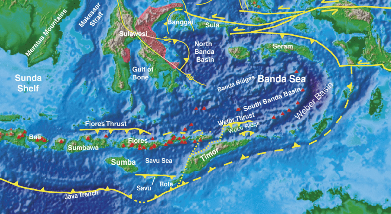
Banda Arc
The Banda Arc, a west facing horse-shoe shaped arc in eastern Indonesia situated west of Papua and in the easternmost extension of the Sunda subduction zone system, defines the locus of three converging and colliding major plates, the Indo-Australian Plate, the Pacific Plate and the Eurasian Plate, and reveals a characteristic bowl-shaped geometry in seismic tomographic images. Splinters of the Mesozoic southern Tethyan crust now form the base of the Banda Sea. On the surrounding islands, dismembered ophiolites can be found in high mountains. Recent studies in the metamorphic aureoles at the base of these ophiolites have revealed a new alternative for the explanation of the complex tectonic development of the arc, ie by invoking obduction as being the major mechanism in the emplacement of southern Tethyan crust onto the passive Australian continental margin.

The Banda Sea encircled by the Banda Arc occupies the main portion of the Banda Sea Plate. Frequent and significant earthquakes, tsunamis and volcano eruptions took place in one of the most complex tectonic regions on Earth, in the general framework of the triple collision of continental Australia plate, oceanic Pacific plates and the southernmost tip of the Eurasian plate, called ‘Sundaland’. The region is composed of a large number of geological provinces. In particular, the eastern termination of the Banda Sea features a number of strongly curved, concentric tectonic provinces.
The USGS records of the largest earthquakes in the world since 1900 show that the earthquake in Banda Sea on February 1, 1938 with a magnitude of 8.5 is among them. Another at least 10 occurrences of large earthquakes in this region between 17th and 20th centuries are also known (Wichmann, 1918, 1923; Harris and Major, 2012). The NOAA records of the world’s deadliest tsunamis from 1650 BC to 2010 AD cited from the National Geophysical Data Center show that 3 occurrences of deadliest tsunamis in the region are among them: in 1674, 1899 and 1992. Unfortunately, no investigation of deposits of ancient tsunamis is carried out in the region. Mount Tambora eruption in 1815 was the largest volcanic eruption in recorded history, caused global climate anomalies that included the phenomenon known as “volcanic winter”: 1816 became known as the “year without a summer” because of the effect on North American and European weather. Crops failed and livestock died in much of the Northern Hemisphere, resulting in the worst famine of the 19th century.

Locations for recorded historical tsunamis. Year of occurrence is indicated for some events. Yellow markers indicate non-seismic or unknown sources, red markers indicate seismic sources. Large stars display magnitudes M ≥ 8.5, small stars 8.5 > M ≥ 8.0, squares 8.0 > M ≥ 7.5, circles M < 7.5, an asterisk means that no magnitude is reported. Upward-pointing triangles indicate volcanoes or combinations of volcanoes and other sources, and downward-pointing triangles indicate landslides or combined landslides/earthquakes. Diamonds indicate unknown sources.
Dynamics of Tsunami
Tsunamis, like the ordinary wind waves, can undergo shoaling, refraction, reflection and diffraction. Most tsunami generated by large earthquakes travel in wave trains containing several large waves. In some cases, the waves in a tsunami wave train consist of an initial peak that then tapers off in height exponentially over 4 to 6 times. In other cases, the tsunami wave train consists of a maximum wave peak well back in the wave sequence.
The time it takes for a pair of wave crests to pass by a point is termed the wave period. This is a crucial parameter in defining the nature of any wave. Tsunamis typically have periods of 100 – 2,000 seconds (1.6 – 33 minutes), referred to as the tsunami window. Waves with this period travel at speeds of 600 – 900 km/hr (166 – 250 m/s) in the deepest part of the ocean, 100 – 300 km/hr (28 – 83 m/s) across the continental shelf, and 36 km/hr (10 m/s) at shore (Iida and Iwasaki, 1983). Because of the finite depth of the ocean and the mechanics of wave generation by earthquakes, a tsunami’s wavelength – the distance between successive wave crests – lies between 10 and 500 kilometers. These long wavelengths make tsunami profoundly different from swell or storm waves.
The simplest form of ocean waves is sinusoidal in shape and oscillatory. Oscillatory waves are described for convenience by three parameters: their height (H), their wavelength (L), and their water depth (d). In deep water, the most significant factor is the ratio H/L, or wave steepness. In shallow water it is the ratio H/d, or relative height. For local tsunamis propagation in water depths greater than 50 meters, these ratios are much less than one. This implies that wave height relative to wavelength is very low – a feature characterizing tsunami in the open ocean.

Shallow water begins when the depth of water (d) is less than half the wavelength (L). As oceans are rarely more than 5 kilometers deep, the majority of tsunamis travel as shallow-water waves. In this case, the velocity of the wave is C = (gd)0.5 and the wave length is L = CT; where g = gravitational acceleration (~9.8 m/s2) and T = wave period. The latter equation holds for linear, sinusoidal waves and is not appropriate for calculating the wavelength of a tsunami as it moves into shallow water. Linear theory can be used as a first approximation to calculate changes in tsunami wave height as the wave moves across an ocean and undergoes wave shoaling and refraction. The following formulae apply: Hi = KrKsHo, Kr = (bo/bi)0.5 and Ks = (do/di)0.25; whereKr = refraction coefficient, Ks = shoaling coefficient, b = distance between wave orthogonals and d = water depth. Subscripts o and i denote at a source point and at any shoreward point, respectively. For a tsunami wave traveling from a distant source, the wave path or ray must also be corrected for geometrical spreading.
Tsunami are known for their dramatic run-up heights, which commonly are greater than the height of the tsunami approaching shore by a factor of 2 or more times. Tsunamis, having long periods of 100 – 2,000 seconds, can also be excited or amplified in height within harbors and bays if their period approximates some harmonic of the natural frequency of the basin – termed resonance. Here tsunami can oscillate back and forth for 24 hours or more. The oscillations are termed seiches. Seiches are independent of the forcing mechanism and are related simply to the 3-dimensional form of the bay. For a closed basin, Ts = 2Lb(gd)-0.5 and for an open basin, Ts = 4Lb(gd)-0.5; where Lb = length of a basin and Ts = wave period of seiching in a bay.
Say, there was an earthquake in the Flores Sea or Makassar Strait in Atlantis era causing an initial wave of 10 meter high. The sea depth was about 1,000 meters. The wave velocity was then C = (9.8 × 1,000)0.5 ≈ 100 m/s (360 km/hr). With an average Java Sea depth of 10 meters (in the era of Atlantis), assuming Kr = (1/4)0.5 ≈ 0.5 and Ks = (1,000/10)0.25 ≈ 3.2, by a simple calculation, the wave height was Hi = 0.5 × 3.2 × 10 ≈ 16 meters in the ancient Java Sea. Approaching the shoreline with a depth of 2 meters (assuming Kr = 1 and Ks = (10/2)0.25 ≈ 1.5), the wave height was Hi = 1 × 1.5 × 16 ≈ 24 meters and the run-up could be twice. It was really a destructive wave and penetrated inland on a very flat plain. In fact, the recorded run-up of 1674 AD Banda Sea tsunami was much larger, 80 – 100 meters high on Ambon Island. Thus, we could speculate that the destruction of Atlantis was among others caused by a tsunami. It was due to the tsunami waves traveling in shallow water (ancient Java Sea) and penetrated inland on a very flat plain. The Meltwater Pulse 1A was probably also contributed the occurrence of earthquakes and tsunamis due to speedy increase of water burden on the Banda Sea Plate.
In Atlantis era, the Java Sea was forming a gulf with a rather narrow entrance and due to the many islands in it resonances and seiches might also occur, causing the wave became much higher and prolonged, and then aggravated its destructive nature.
***
No comments:
Post a Comment